
Nalgonda District Overview

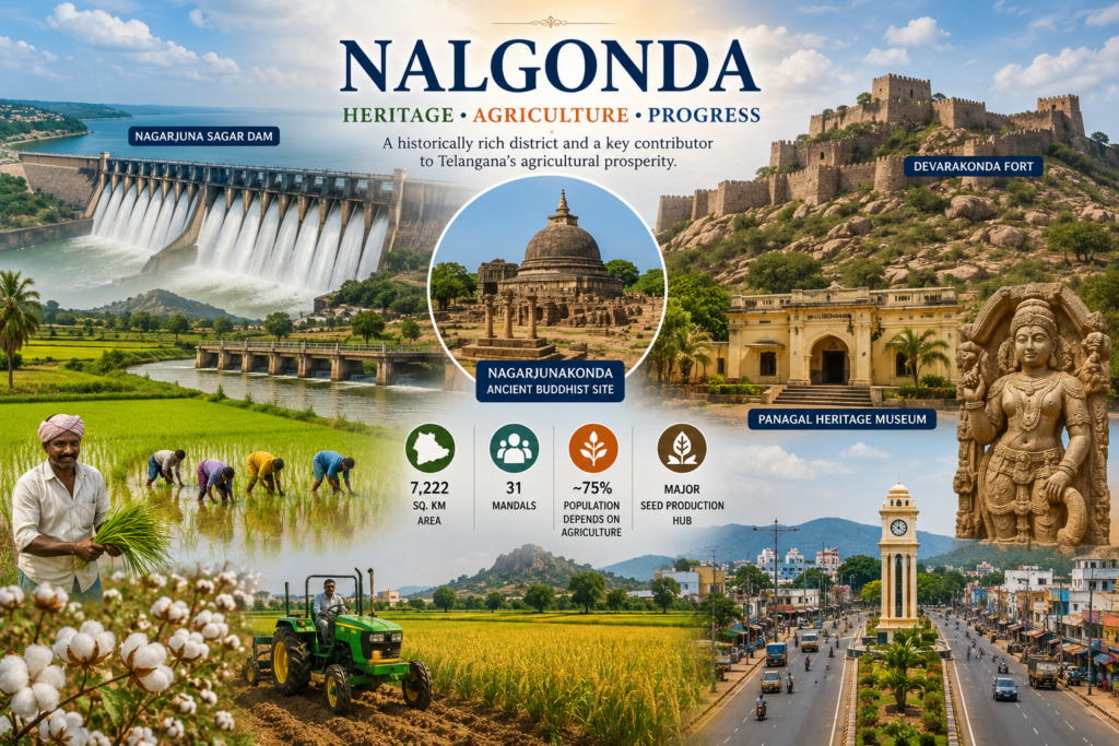
Nalgonda is a historically rich and agriculturally important district in Telangana, located about 100 km southeast of Hyderabad. Covering 7,222 sq. km with 31 mandals, it is the state’s second-largest district and a major contributor to agriculture and seed production. Nearly 75% of the population depends on farming, with paddy and cotton being the primary crops. Supported by extensive irrigation networks, Nalgonda plays a key role in Telangana’s agricultural economy.
The district derives its name from the Telugu words Nalla (black) and Konda (hill). Its history stretches back to the Paleolithic era and reflects the influence of Buddhist, Hindu, and Muslim dynasties. Nalgonda is home to several prominent attractions, including the historic Nagarjuna Sagar Dam, the ancient Buddhist site of Nagarjunakonda, the majestic Devarakonda Fort, and the Panagal Heritage Museum. Combining rich heritage, cultural significance, and agricultural strength, Nalgonda remains one of Telangana’s most important districts.
Major Towns and Municipalities of Nalgonda District
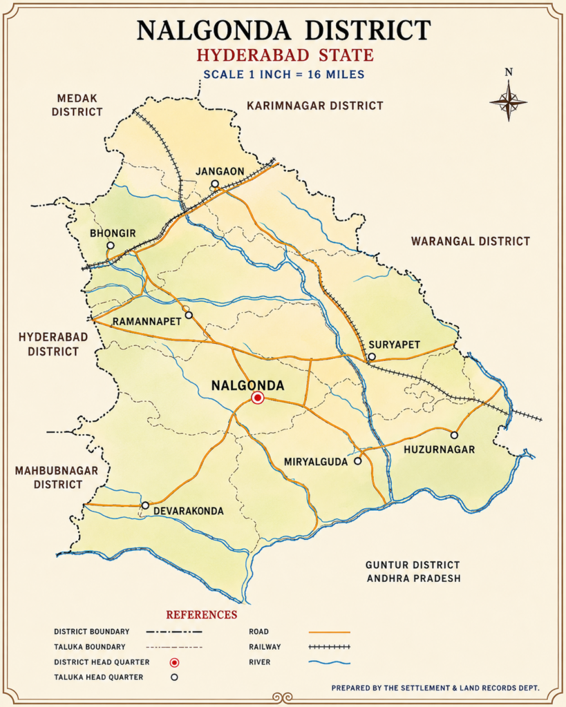
Nalgonda district comprises several important municipalities and urban centers that contribute to its administration, economy, agriculture, and tourism.
- Nalgonda – District headquarters and the primary administrative and commercial center.
- Miryalaguda – Major agricultural and rice-trading hub of the district.
- Devarakonda – Famous for the historic Devarakonda Fort and cultural heritage.
- Nakrekal – Important business and transportation center on the Hyderabad–Vijayawada route.
- Chandur – Growing municipal town known for agriculture and local commerce.
- Chityala – Developing urban center serving nearby rural communities.
- Haliya (Anumula) – Significant agricultural town benefiting from irrigation facilities.
- Nandikonda – Known for its Buddhist heritage and archaeological importance.
- Choutuppal – Rapidly growing industrial and residential town near Hyderabad.
- Nagarjuna Sagar – Renowned for the world-famous Nagarjuna Sagar Dam and tourism attractions.
These towns serve as key centers for trade, education, transportation, and public services across the district. Their strategic locations and growing infrastructure support both urban and rural development. Together, they play a crucial role in strengthening Nalgonda’s economy and improving the quality of life for its residents.
Population & Demographics of Nalgonda District
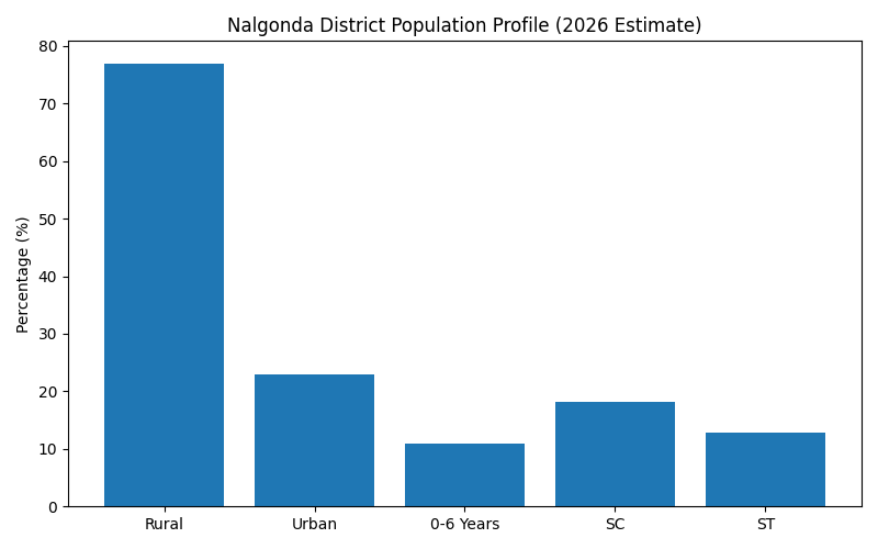
Nalgonda district is one of Telangana’s largest and predominantly rural districts, with an estimated population of approximately 17.55 lakh (1.75 million) in 2026. Covering an area of about 7,122 sq. km, the district continues to maintain its strong agricultural character, with nearly 77% of residents living in rural areas and depending directly or indirectly on farming and allied activities. Major crops such as paddy, cotton, maize, and pulses form the backbone of the local economy.
According to demographic trends based on the 2011 Census and subsequent projections, Nalgonda has an estimated rural population of 13.58 lakh and an urban population of 3.96 lakh in 2026. The district maintains a favorable sex ratio of 978 females per 1,000 males, reflecting a relatively balanced population structure. The literacy rate stands at 63.75%, with male literacy at 73.9% and female literacy at 53.5%. Scheduled Castes and Scheduled Tribes constitute a significant portion of the population at 18.1% and 12.9% respectively. The district is predominantly Hindu, while Muslim and Christian communities also contribute to its cultural diversity. These demographic characteristics highlight Nalgonda’s blend of rural strength, agricultural importance, and social diversity, making it one of Telangana’s key districts.
Quick Demographic Highlights
- 👥 Estimated Population (2026): 17.55 lakh
- 🌾 Rural Population: 77%
- 🏙️ Urban Population: 23%
- 👶 Children (0-6 years): About 1.97 lakh
- ⚖️ Sex Ratio: 978 females per 1,000 males
- 📚 Literacy Rate: 63.75%
- 🏛️ SC Population: 18.1%
- 🌿 ST Population: 12.9%
- 🕉️ Major Religion: Hinduism (about 93%)
📊 Population Representation (2026 Estimate)
| Category | Population | Share (%) |
|---|---|---|
| Total Population | 17,54,687 | 100% |
| Rural Population | 13,58,000 | 77% |
| Urban Population | 3,96,000 | 23% |
| Children (0-6 Years) | 1,97,000 | 11% |
| Scheduled Castes (SC) | 3,17,000 | 18.1% |
| Scheduled Tribes (ST) | 2,26,000 | 12.9% |
Nalgonda District Statistics & Demographic Profile
Nalgonda is one of Telangana’s most important districts, known for its agricultural strength, historical heritage, and growing urban development. Located in southern Telangana, the district continues to play a significant role in the state’s economy through farming, irrigation projects, education, and trade. With a predominantly rural population and a strong agricultural base supported by the Krishna River basin, Nalgonda remains a key contributor to Telangana’s growth.
Key Statistics
| Statistic | Value |
|---|---|
| Estimated Population (2026) | 37.5 Lakh |
| Area | 7,122 sq. km |
| Postal Codes | 246 |
| Sex Ratio | 978 Females per 1000 Males |
| Rural Population | 77.24% |
| Urban Population | 22.76% |
| Literacy Rate | 65.5% |
| Male Literacy | 74% |
| Female Literacy | 53% |
| Scheduled Castes (SC) | 18.10% |
| Scheduled Tribes (ST) | 12.93% |
| Primary Economic Sector | Agriculture |
| Major Crops | Paddy, Cotton, Maize, Pulses |
📈 Chart Representation
1. Urban vs Rural Population
Rural Population ██████████████████████████████████████ 77.24%
Urban Population ███████████ 22.76%
2. Literacy Rate Comparison
Male Literacy ██████████████████████████████████ 74%
Female Literacy ████████████████████████ 53%
Overall Literacy ███████████████████████████ 65.5%
3. Social Composition
General Category ████████████████████████████████ 68.97%
SC Population ████████ 18.10%
ST Population █████ 12.93%
4. Population Distribution
Total Population ████████████████████████████████████ 37.5 Lakh
Rural Population █████████████████████████████ 28.96 Lakh
Urban Population █████████ 8.54 Lakh
Area and Geographical Profile of Nalgonda District
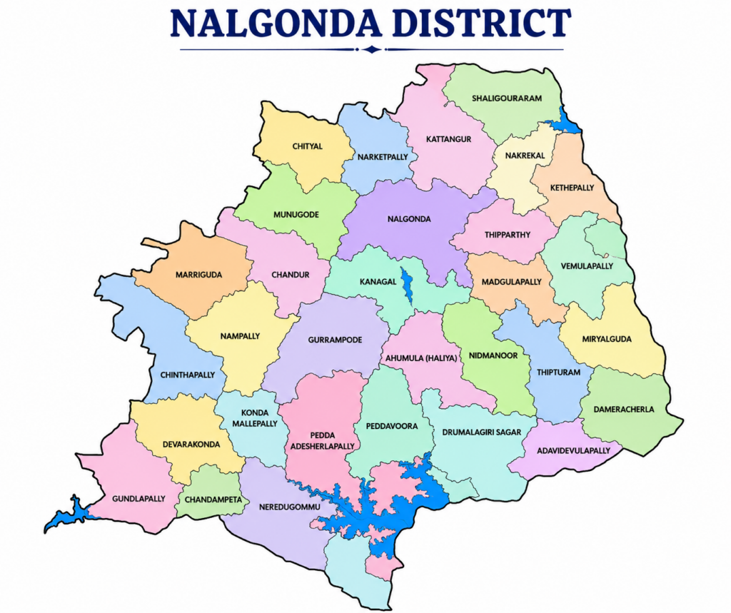
Nalgonda district is one of the largest and most geographically significant districts in Telangana. Covering a total area of 7,122 square kilometers (2,750 square miles), it ranks as the second-largest district in the state by area. The district is strategically located in southern Telangana and serves as an important center for agriculture, administration, transportation, and regional development.
The district shares its boundaries with Suryapet, Yadadri Bhuvanagiri, Rangareddy, and Nagarkurnool districts, while its southern boundary adjoins the state of Andhra Pradesh. Nalgonda is administratively divided into 31 mandals, the highest number of mandals among all districts in Telangana, enabling efficient governance and service delivery across both urban and rural regions.
The district’s landscape consists of fertile agricultural plains, rocky hill formations, river basins, reservoirs, and forested areas. The Krishna River and major irrigation projects, including the Nagarjuna Sagar Dam, play a crucial role in supporting agriculture and water resources throughout the district.
Nalgonda receives an average annual rainfall of approximately 670.2 mm, against a normal rainfall level of 751 mm, making irrigation infrastructure vital for sustaining agricultural activities. Its vast geographical area, diverse landscape, and strategic location have contributed significantly to its historical, economic, and cultural importance within Telangana.
📏 Nalgonda District Area at a Glance
| Parameter | Details |
|---|---|
| Total Area | 7,122 sq. km |
| Area in Square Miles | 2,750 sq. mi |
| State | Telangana |
| District Rank by Area | 2nd Largest in Telangana |
| Headquarters | Nalgonda |
| Number of Mandals | 31 |
| Average Rainfall | 670.2 mm |
| Normal Rainfall | 751.0 mm |
| Major River Basin | Krishna River Basin |